Note
Go to the end to download the full example code
Earth Coordinate Conversion#
In this tutorial, we will show how to place actors on specific locations on the surface of the Earth using a new function.
import itertools
import math

import numpy as np

import fury
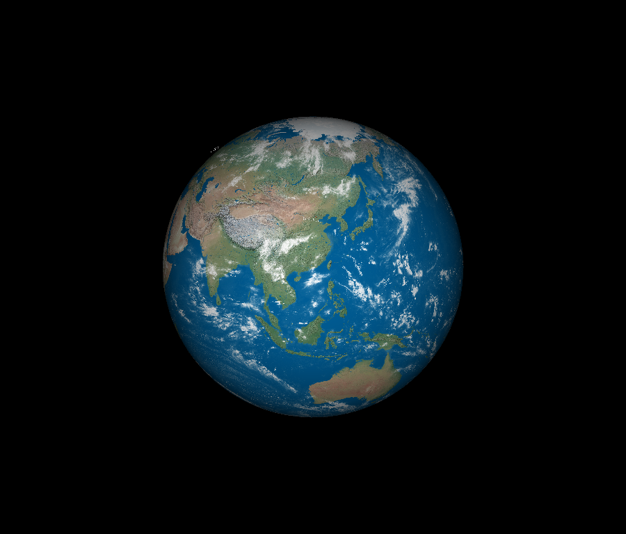
Create a new scene, and load in the image of the Earth using
fetch_viz_textures and read_viz_textures. We will use a 16k
resolution texture for maximum detail.
scene = fury.window.Scene()

fury.data.fetch_viz_textures()
earth_file = fury.data.read_viz_textures("1_earth_16k.jpg")
earth_image = fury.io.load_image(earth_file)
earth_actor = fury.actor.texture_on_sphere(earth_image)
scene.add(earth_actor)
Dataset is already in place. If you want to fetch it again please first remove the folder /Users/skoudoro/.fury/textures
/opt/homebrew/Caskroom/miniforge/base/envs/py311-fury/lib/python3.11/site-packages/PIL/Image.py:3186: DecompressionBombWarning: Image size (131220000 pixels) exceeds limit of 89478485 pixels, could be decompression bomb DOS attack.
  warnings.warn(
Rotate the Earth to make sure the texture is correctly oriented. Change it’s
scale using actor.SetScale().
fury.utils.rotate(earth_actor, rotation=(-90, 1, 0, 0))
fury.utils.rotate(earth_actor, rotation=(180, 0, 1, 0))
earth_actor.SetScale(2, 2, 2)
Define the function to convert geographical coordinates of a location in
latitude and longitude degrees to coordinates on the earth_actor surface.
In this function, convert to radians, then to spherical coordinates, and
lastly, to cartesian coordinates.
def latlong_coordinates(lat, lon):
    # Convert latitude and longitude to spherical coordinates
    degrees_to_radians = math.pi / 180.0
    # phi = 90 - latitude
    phi = (90 - lat) * degrees_to_radians
    # theta = longitude
    theta = lon * degrees_to_radians * -1
    # now convert to cartesian
    x = np.sin(phi) * np.cos(theta)
    y = np.sin(phi) * np.sin(theta)
    z = np.cos(phi)
    # flipping z to y for FURY coordinates
    return (x, z, y)
Use this new function to place some sphere actors on several big cities around the Earth.
locationone = latlong_coordinates(40.730610, -73.935242)  # new york city, us
locationtwo = latlong_coordinates(39.916668, 116.383331)  # beijing, china
locationthree = latlong_coordinates(48.864716, 2.349014)  # paris, france
Set the centers, radii, and colors of these spheres, and create a new
sphere_actor for each location to add to the scene.
centers = np.array([[*locationone], [*locationtwo], [*locationthree]])
colors = np.random.rand(3, 3)
radii = np.array([0.005, 0.005, 0.005])
sphere_actor = fury.actor.sphere(centers, colors, radii=radii)
scene.add(sphere_actor)
Create some text actors to add to the scene indicating each location and its geographical coordinates.
nyc_actor = fury.actor.text_3d(
    "New York City, New York\n40.7128° N, 74.0060° W",
    position=(locationone[0] - 0.04, locationone[1], locationone[2] + 0.07),
    color=fury.window.colors.white,
    font_size=0.01,
)
paris_actor = fury.actor.text_3d(
    "Paris, France\n48.8566° N, 2.3522° E",
    position=(locationthree[0] - 0.04, locationthree[1], locationthree[2] - 0.07),
    color=fury.window.colors.white,
    font_size=0.01,
)
beijing_actor = fury.actor.text_3d(
    "Beijing, China\n39.9042° N, 116.4074° E",
    position=(locationtwo[0] - 0.06, locationtwo[1], locationtwo[2] - 0.07),
    color=fury.window.colors.white,
    font_size=0.01,
)
fury.utils.rotate(paris_actor, rotation=(85, 0, 1, 0))
fury.utils.rotate(beijing_actor, rotation=(180, 0, 1, 0))
fury.utils.rotate(nyc_actor, rotation=(5, 1, 0, 0))
Create a ShowManager object, which acts as the interface between the scene, the window and the interactor.
showm = fury.window.ShowManager(
    scene=scene, size=(900, 768), reset_camera=False, order_transparent=True
)
Let’s create a timer_callback function to add some animation to the
Earth. Change the camera position and angle to fly over and zoom in on each
new location.
counter = itertools.count()


def timer_callback(_obj, _event):
    cnt = next(counter)
    showm.render()
    if cnt == 0:
        scene.set_camera(position=(1.5, 3.5, 7.0))
    if cnt < 200 and cnt > 25:
        scene.zoom(1.015)
        scene.pitch(0.01)
    if cnt == 200:
        scene.add(nyc_actor)
    if cnt > 250 and cnt < 350:
        scene.zoom(0.985)
    if cnt > 350 and cnt < 425:
        scene.azimuth(1)
    if cnt > 425 and cnt < 525:
        scene.zoom(1.015)
        scene.pitch(0.011)
    if cnt == 525:
        scene.add(paris_actor)
    if cnt > 575 and cnt < 700:
        scene.zoom(0.985)
    if cnt > 700 and cnt < 820:
        scene.azimuth(1)
    if cnt > 820 and cnt < 930:
        scene.zoom(1.015)
    if cnt == 930:
        scene.add(beijing_actor)
    if cnt == 1000:
        showm.exit()
Initialize the ShowManager object, add the timer_callback, and watch the new animation take place!
showm.add_timer_callback(True, 25, timer_callback)
showm.start()

fury.window.record(
    scene=showm.scene, size=(900, 768), out_path="viz_earth_coordinates.png"
)
Total running time of the script: (0 minutes 27.999 seconds)